Hurricane Isaias surges toward Carolinas with 85 mph winds
[ad_1]
Almost a month after Fay, another tropical storm is set to impact the Northeast.
Accuweather
Story Highlights
- Isaias is forecast to make landfall as a hurricane in the Carolinas Monday night.
- Flood watches were posted all the way from the Carolinas to New England.
- The storm could also spin up a few tornadoes, the hurricane center said.
Isaias, which began Monday as a tropical storm, strengthened into a Category 1 hurricane in the evening as it took aim at the Carolinas.
Hurricane Isaias is forecast to make landfall in the Carolinas on Monday night and will bring dangerous storm surge and flash flooding to most of the Eastern Seaboard over the next few days, the National Weather Service said.
The National Hurricane Center issued a hurricane warning from South Santee River, South Carolina, to Surf City, North Carolina.
Follow Isaias: For first-in-the-morning updates, sign up to get USA TODAY’s Daily Briefing in your inbox
“We are forecasting it to become a hurricane before it reaches the coast this evening,” senior hurricane specialist Daniel Brown said. “It’s forecast to produce a dangerous storm surge of 3 to 5 feet in portions of North and South Carolina.”
Calling the surge “life threatening,” the hurricane center warned that “the combination of a dangerous storm surge and the tide will cause normally dry areas near the coast to be flooded by rising waters moving inland from the shoreline.”
Isaias – pronounced ees-ah-EE-ahs – could bring heavy rains, too – up to 8 inches in spots as it moves up the coast, Brown said, and “all those rains could produce flash flooding across portions of eastern Carolinas and mid-Atlantic, and even in the Northeast U.S.”
President Donald Trump, speaking during a Monday press briefing, said he has issued emergency declarations for Florida, South Carolina and North Carolina. He added personnel from FEMA are “on the ground in all areas.”
A tropical storm warning was in effect for a huge portion of the eastern U.S., all the way from Georgia to Massachusetts, impacting 114 million Americans, according to the Weather Service.
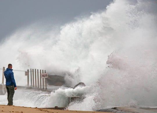
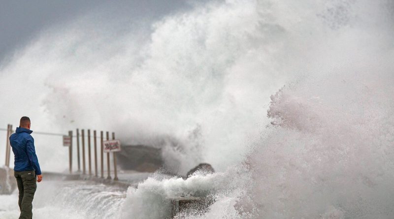
Waves driven by Tropical Storm Isaias crash over the jetty on the north side of the Palm Beach Inlet in Palm Beach Shores, Fla., Sunday, Aug. 2, 2020. (Photo: Lannis Waters, AP)
As of 9 p.m. Monday, the center of Isaias was located 55 miles south-southeast of Myrtle Beach, South Carolina, moving north-northeast at 18 mph, the hurricane center said. The storm’s maximum sustained winds winds clocked in at 85 mph.
“Some additional strengthening is possible before landfall,” the National Hurrcaine center wrote in its 8 p.m. advisory. “Only gradual weakening is anticipated after Isaias makes landfall in the Carolinas and moves across the U.S. mid-Atlantic region tonight and Tuesday.”
Flood watches were posted all the way from the Carolinas to New England. In all, about 54 million people live where flood watches are in effect. These watches include the Washington, Baltimore, Philadelphia and New York City metro areas.
Hurricane center director Ken Graham said 90% of fatalities from tropical storm systems are from water. “So that’s a dangerous situation – too much precipitation,” Graham said. “If you’re out and about, don’t drive your car where water covers the road.”
There could also be power outages and some tree damage in areas that experience stronger wind gusts along the East Coast, Weather.com said. This includes areas from the eastern Carolinas to the coastal mid-Atlantic, New York City, Long Island and parts of eastern New England.
The storm could also spin up a few tornadoes, the hurricane center said. The tornadoes will be possible over coastal South Carolina beginning Monday evening, spreading across eastern North Carolina into Tuesday morning.
Tornadoes will also be possible on Tuesday from eastern Virginia northeastward into southern New England.
Isaias is the earliest named ninth Atlantic tropical cyclone on record, Weather.com said. The previous record was Irene on Aug. 7, 2005.
A timelapse captured along the beach in Fort Lauderdale, Florida, shows clouds from Isaias sweeping through the area.
Accuweather
Meanwhile, forecasters were watching yet another system out in the Atlantic. A weather disturbance located a few hundred miles north of the Leeward Islands is producing disorganized showers and thunderstorms, the hurricane center said. “Environmental conditions could allow for some slow development of this system during the next several days, with a tropical depression possibly forming later this week,” the hurricane center said.
Contributing: The Associated Press; Haley Walters, Greenville (S.C.) News
Read or Share this story: https://www.usatoday.com/story/news/nation/2020/08/03/tropical-storm-isaias-track-forecast-become-hurricane-carolinas/5571118002/