Tropical Storm Laura, Marco path: Hurricane status, Fujiwhara effect
[ad_1]
The National Hurricane Center is monitoring two tropical depressions that are expected to reach hurricane strength in the Gulf of Mexico.
Video Elephant
There are now two tropical storms in the Atlantic Ocean, both of them heading toward the Gulf of Mexico, and forecasters aren’t sure what will happen when they both get there.
Tropical Storm Marco formed Friday night over the northwestern Caribbean Sea and is forecast to move near the Yucatan Peninsula on Saturday, joining Tropical Storm Laura which is nearing the Dominican Republic.
Both storms are forecast to strike the U.S. within a day of each other, forecasters said. Marco’s path is heading toward Texas, while Laura’s path has moved away from Florida and toward Louisiana, Mississippi and Alabama.
There have never been two hurricanes in the Gulf of Mexico at the same time, and it may not happen now, either. Forecasters now believe Marco will make landfall in Texas as a tropical storm.
Could hurricanes collide?: Could hurricanes collide? Here’s what may happen if Laura and Marco meet up in the Gulf
Both Laura and Marco are posing significant forecast challenges for the National Hurricane Center. Weather models varied widely on future intensities, with some forecast models predicting Laura striking the U.S. as a major hurricane nearing the U.S., while others see it dissipating. And how the storms will affect each other in the Gulf of Mexico remains a puzzle.
Tropical Storm Laura
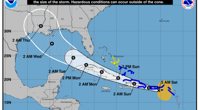
As of the 5 a.m. advisory from the National Hurricane Center, Laura was 70 miles southeast of San Juan, Puerto Rico, with 40 mph winds and moving west at 21 mph.
The storm is forecast to reach hurricane strength early next week in the Gulf of Mexico before making landfall Wednesday somewhere between Florida’s Panhandle and western Louisiana with 75 mph winds.
The center of a “disorganized” Laura is currently over the Virgin Islands and eastern Puerto Rico and is expected to move across much of the greater Antilles this weekend, according to the hurricane center, dropping 3 to 6 inches of rain over Puerto Rico and the Virgin Islands, the Dominican Republic, the southern Haitian Peninsula and eastern Cuba through Sunday.
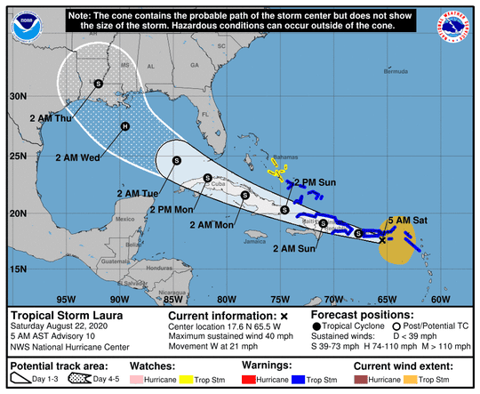
Tropical Storm Laura approaches the Dominican Republic Saturday morning. (Photo: National Hurricane Center)
If Laura goes over land, Puerto Rico and the mountains of Haiti, the Dominican Republic and Cuba could tear it apart and not make it much of a threat to the mainland United States, meteorologists said. But if it misses or skirts land, it could head into warm waters conducive to strengthening as it approaches Florida, meteorologists said.
Laura may pass over the Florida Keys en route to the Gulf. Officials there declared a local state of emergency Friday and issued a mandatory evacuation order for anyone living on boats, in mobile homes and in campers.
Tropical Storm Marco
At 5 a.m. Marco was 115 miles east-southeast of Cozumel, Mexico, with 45 mph sustained winds, moving north-northwest at 12 mph.
The center of Marco will approach the east coast of the Yucatan Peninsula of Mexico on Saturday, the hurricane center said, approaching the northeastern part of the Yucatan Peninsula by early evening and moving over the central Gulf of Mexico on Sunday and Monday.
Marco is expected to strengthen during the next couple of days and could be near hurricane strength when it moves over the Gulf on Sunday night and early Monday.
While meteorologists said Marco has a better chance of surviving its early land encounter, then strengthening to a minimal hurricane over warm water, the hurricane center was forecasting it to weaken before it reaches the U.S. Gulf Coast because of decapitating high winds.
Citing both storm systems, Louisiana Gov. John Bel Edwards declared a state of emergency Friday night. “It is too soon to know exactly where, when or how these dual storms will affect Louisiana, but now is the time for our people to prepare for these storms,” Edwards said in a statement.
What happens if they meet up in the Gulf of Mexico? What is the Fujiwhara effect?
The two storms are forecast to be together in the Gulf on Tuesday. If they make it, they’d be about 550 miles apart.
If Laura and Marco are close enough together – which may or may not occur – what could happen is something called the Fujiwhara effect, which describes the rotation of two storms around each other. It’s most common with tropical cyclones such as typhoons or hurricanes, but it also occurs in other cases.
When two hurricanes spinning in the same direction pass close enough to each other, they begin an intense dance around their common center, the National Weather Service said. The effect is thought to occur when storms get about 900 miles apart.
Storms involved in the Fujiwhara effect are rotating around one another as if they had locked arms and were square dancing.
Yet, the Gulf of Mexico has its limitations when two storms vie for dominance. Some experts said the watery crater created by plate tectonics (the Gulf) is too small for the legendary Fujiwhara effect.
Instead, one storm typically dominates another in such a confined space, either pushing it away or tearing it apart with tendrils of cirrus clouds marking its own cyclone-toppling wind shear.
AccuWeather senior meteorologist Dan Kottlowski said he believes Marco will be the bigger storm, its counterclockwise swirl shoving Laura into the coast faster than what might be forecast.
But there’s still a chance the storms may not make it to the Gulf as hurricanes.
“It’s still on the table that both of these may fizzle out,” senior meteorologist Jonathan Erdman of Weather.com, said. “This could all be for naught, which might be the most 2020 thing of them all.”
Contributing: Seth Borenstein and Freida Frisaro, Associated Press; Doyle Rice, USA TODAY
Read or Share this story: https://www.usatoday.com/story/news/nation/2020/08/22/tropical-storm-laura-marco-path-gulf-mexico-hurricane-status/3418693001/