Winter storm warnings in Northeast: National weather forecast updates
[ad_1]

Winter storm warnings were in effect in more than a half-dozen states Monday morning, especially in parts of the Northeast, where tens of thousands of people were without power.
“We have two storm systems that will impact the country this week,” Alyssa Clements, a meteorologist with the National Weather Service told USA TODAY Monday.
One storm system will organize over the Southwest U.S. on Monday before becoming a large-scale winter storm system and ejecting into the southern Plains on Tuesday, Clements said.
The storm will likely impact portions of the Central, Southern and Eastern U.S. through midweek with a variety of hazards, including a swath of heavy snow and severe thunderstorms with heavy rainfall.
Meanwhile, parts of New England were being pelted by snow Monday. Here’s what to know:
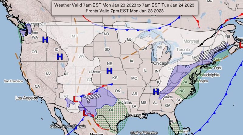
Northeast facing 6-12 inches of snow
The storm system hitting the Northeast is ongoing, she said, and will last through Monday night across the Northeast, affecting the New England area from New York into Maine.
Heavy snow and coastal rain are expected over parts of the Northeast.
The region could get anywhere from 6-12 inches of snow by Monday night, Clements said.
“That first system expected to hit New England will move out overnight and it will be quieter in that area through Thursday,” she said.
Power outages reported in Massachusetts, New Hampshire
More than 45,700 homes and businesses were without power in New Hampshire and Massachusetts Monday morning as the first storm rolled through New England.
In New Hampshire, Eversource’s outage map reported more than 33,358 power outages and New Hampshire Electric Co-op reported more than 2,129 power outages as of 11:15 a.m. local time.
In Massachusetts, 10,262 people were without power as of 11:15 a.m., according to the Massachusetts Emergency Management Agency map.
Winter storm brewing in Southwest
Meanwhile, a second winter storm began forming Monday across the Southwest, where it will strengthen in Arizona and New Mexico and eventually bring snow, Clements said.
New Mexico could see anywhere from 4-10 inches of snow across its eastern plains, Clements said.
The system will track through portions of Oklahoma and Texas on Tuesday and into the Midwest on Wednesday.
Oklahoma could see 2-4 inches of snow and the Texas panhandle may get 6-8 inches, NWS forecasters say.
Active winter storm warnings
As of Monday morning, winter storm warnings were active in areas of eastern New York, western New England, northern Vermont, New Hampshire and most of Maine, the National Weather Service reported.
They were also active in New Mexico and as well as in Lubbock, Texas, and the northern part of the state.
Potentially severe thunderstorms forecast in Mississippi, Alabama, Louisiana
Meanwhile, Tuesday night, thunderstorms will break across portions of the Gulf Coast in Mississippi, Alabama and Louisiana.
Potential severe storms area expected in those areas overnight Tuesday, Clements said.
Noteworthy snow is also expected to affect much of Arkansas and western Tennessee.
In addition, a slight risk of excessive rainfall is in effect from eastern Texas to south-central Mississippi, where rainfall totals could exceed 2 inches in some areas.
Light snow possible in North Dakota, Minnesota and Great Lakes
Elsewhere across the U.S. Monday, light snow was likely across parts of North Dakota, Minnesota, and into the northern Great Lakes as a fast-moving low-pressure system moves through the region.
Patchy areas of light snow are expected across the Rockies, the NWS said.
National weather radar
Natalie Neysa Alund covers trending news for USA TODAY. Reach her at nalund@usatoday.com and follow her on Twitter @nataliealund.